


HAVERFORD TWP WD 08 PCT 02, Delaware County, Pennsylvania
About
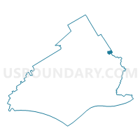
Outline

Summary
| Unique Area Identifier | 659231 |
| Name | HAVERFORD TWP WD 08 PCT 02 |
| County | Delaware County |
| State | Pennsylvania |
| Area (square miles) | 0.31 |
| Land Area (square miles) | 0.31 |
| Water Area (square miles) | 0.00 |
| % of Land Area | 100.00 |
| % of Water Area | 0.00 |
| Latitude of the Internal Point | 39.97706490 |
| Longtitude of the Internal Point | -75.28435410 |
Maps

Graphs
Select a template below for downloading or customizing gragh for HAVERFORD TWP WD 08 PCT 02, Delaware County, Pennsylvania


Neighbors
Neighoring Voting District (by Name) Neighboring Voting District on the Map
- HAVERFORD TWP WD 08 PCT 01, Delaware County, PA
- HAVERFORD TWP WD 08 PCT 03, Delaware County, PA
- LOWER MERION TWP WD 14 PCT 01, Montgomery County, PA
- LOWER MERION TWP WD 14 PCT 03, Montgomery County, PA
- PHILADELPHIA WD 34 PCT 31, Philadelphia County, PA
- UPPER DARBY TWP DIST 04 PCT 06, Delaware County, PA
- UPPER DARBY TWP DIST 04 PCT 07, Delaware County, PA
Top 10 Neighboring County Subdivision (by Population) Neighboring County Subdivision on the Map
- Philadelphia city, Philadelphia County, PA (1,526,006)
- Upper Darby township, Delaware County, PA (82,795)
- Lower Merion township, Montgomery County, PA (57,825)
- Haverford township, Delaware County, PA (48,491)
Top 10 Neighboring Place (by Population) Neighboring Place on the Map
Top 10 Neighboring Unified School District (by Population) Neighboring Unified School District on the Map
- Philadelphia City School District, PA (1,526,006)
- Upper Darby School District, PA (90,606)
- Lower Merion School District, PA (62,107)
- Haverford Township School District, PA (48,491)
Top 10 Neighboring State Legislative District Lower Chamber (by Population) Neighboring State Legislative District Lower Chamber on the Map
- State House District 164, PA (63,304)
- State House District 149, PA (61,624)
- State House District 166, PA (60,028)
- State House District 192, PA (55,382)
Top 10 Neighboring State Legislative District Upper Chamber (by Population) Neighboring State Legislative District Upper Chamber on the Map
- State Senate District 26, PA (251,041)
- State Senate District 17, PA (248,670)
- State Senate District 7, PA (239,153)
Top 10 Neighboring 111th Congressional District (by Population) Neighboring 111th Congressional District on the Map
- Congressional District 6, PA (726,465)
- Congressional District 7, PA (673,623)
- Congressional District 1, PA (655,146)
Top 10 Neighboring Census Tract (by Population) Neighboring Census Tract on the Map
- Census Tract 4006, Delaware County, PA (5,316)
- Census Tract 2055.03, Montgomery County, PA (4,827)
- Census Tract 4005, Delaware County, PA (4,235)
- Census Tract 4090, Delaware County, PA (3,721)
- Census Tract 4089, Delaware County, PA (2,933)
- Census Tract 9808, Philadelphia County, PA (6)